Latest Travel Alerts and Warnings for Visitors to New Zealand
What are the issues affecting travelers in New Zealand? Read the latest travel warnings and alerts.
 Photo © Getty Images/georgeclerk
Removal of State of National Emergency - 15 March 2023
This has been replaced by a National Transition period. Check the NZ National Emergency Management Agency website for updates and information.State of emergency - 28 February 2023
The State of National Emergency has been extended to 7 March 2023 in response to the further problems crated by Cyclone Gabrielle. Northland, Auckland, Waikato, Tairāwhiti, and Hawke’s Bay regions, and the Tararua District are affected. The Bay of Plenty is no longer covered by the declaration. Check the NZ National Emergency Management Agency website for updates and information.
Flooding in Auckland and other parts of the North Island – 30 January 2023
The NZ Government has declared a State of National Emergency in the North Island city of Auckland due to severe flooding. The city's airport terminals and surrounding roads have been impacted by the flooding and Auckland Airport has experienced disruption, flight delays and cancellations. Contact your airline or tour operator for the latest information before attempting travel.Floods in the Southland region of New Zealand – February 2020
Flash floods and torrential rain on New Zealand's South Island have left several hundred tourists stranded, and forced residents in the area to evacuate their homes.
Authorities have warned of more floods in the region due to rising water levels in the Mataura River. Many roads were blocked, and power supplies were disrupted in the affected areas, which included the popular travel destinations Milford Sound and Te Anau.
Keep an eye on weather reports and monitor local news closely if you are in the region, or if you are visiting the Southland region soon, contact your travel provider to see how this may change your plans.
Jetstar industrial action – December 2019
Jetstar staff will be conducting a series of strikes on beginning on 13, 14 and 15 December 2019. If you're an Australian or New Zealand resident with a travel insurance policy from World Nomads, find out how this may affect your coverage.
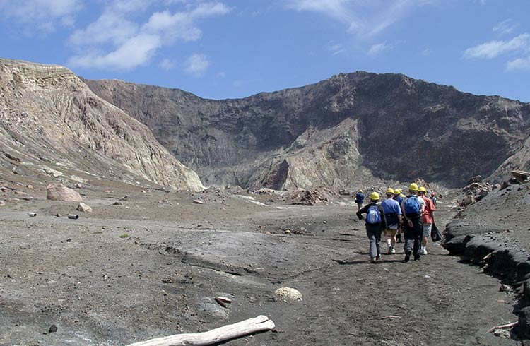
Volcanic eruption on White Island – 9 December 2019
Whakaari/White Island is New Zealand's most active cone volcano, and erupted without warning on Monday, 9 December 2019.
The island lies 29mi (48km) off the east coast of the North Island, in the Bay of Plenty. It last erupted in 2001.
At the time of the eruption, 47 people were on or near the island. Six people have been confirmed dead, eight people are missing, and 31 are in hospital.
If you are on the North Island near the Bay of Plenty, police have advised that volcanic ash could pose a major health hazard.
Stay up to date with local media on the situation, and be aware your plans to visit White Island may be disrupted. Contact your travel provider for more information.
West coast wild weather – March 2019
A state of emergency has been declared for the west coast of New Zealand's South Island due to a severe storm system which have battered the coast since last Sunday night, resulting in heavy rain, flooding and landslides. One person has died and hundreds of people are displaced as the system moves north along the coast. There are power disruptions in several locations.
Many roads and highways have been completely cut off or significantly damaged due to extreme flooding. State Highway 73, between Arthurs Pass and Jacksons, is currently impacted due to two landslides and the Franz Josef-Fox Glacier Highway has been cut off due to the raging Wahio River taking out the WahioBridge, leaving people stranded in Franz Josef unable to travel south towards Fox Glacier and Wanaka. There have also been numerous landslides on the highway between Fox Glacier and Franz Josef. Currently, the only route north along the west coast is via the Lewis Pass. For more information, check out the New Zealand Transport Agency website.
Government authorities have indicated it will take days or weeks to assess and repair roads depending on the severity of damage in affected locations.
Travelers are strongly advised to obey all official signage and warnings from emergency personnel. Do not attempt to drive or walk through floodwaters or closed areas for your own safety. Motorists are also advised to take caution while driving due to road conditions, debris and work crews cleaning up.
Nelson-Tasman bushfire - February 2019
An out of control bushfire is currently burning in the Nelson-Tasman region of New Zealand's South Island. The fast-moving fire started in Pigeon Valley (18.6 mi/30km south of Nelson) on February 5th and has doubled in size overnight, burning 7.22 sq. mi (18.7 sq.km) with a perimeter of 12.4 miles (20km). Over 170 homes have been evacuated as ground crews and water-bombing aircraft fight to get the blaze under control. There are road closures in place.
A state of emergency has been declared by the Tasman and Nelson district mayors. Authorities have ordered people to evacuate if they feel unsafe and if located in the immediate fire zone to make sure they have access to radio and other media for further updates.
Christchurch earthquake - November 2016
Just a week after a severe earthquake struck near Christchurch another strong tremor has been detected off the lower part of the North Island.
The quake measured at magnitude 6.3 hit off the coast of Palmerston North.
Check local media for updates on the quake and reports of the extent of damage.
New Zealand earthquake - November 2016
The north-east of New Zealand’s South Island has been struck by a series of earthquakes, the largest measuring magnitude 7.5. At this time 2 people are confirmed dead.
The major quake struck just after midnight local time on November 14, and has been followed by dozens of smaller tremors measuring up to 6.3 magnitude.
Travelers are warned that many roads in the area north of Christchurch are impassable due to upheaval or landslide. Local authorities are warning people to avoid all but essential travel to the area at this time. Ferry services to the South Island out of Wellington have been canceled until further notice. Check with ferry operators and local media for updates.
Related articles
Simple and flexible travel insurance
You can buy at home or while traveling, and claim online from anywhere in the world. With 150+ adventure activities covered and 24/7 emergency assistance.
Get a quote

No Comments