Vatnajökull National Park: An Adventurer’s Guide
As varied as it is vast, Iceland’s extraordinary Vatnajökull National Park offers glaciers, volcanoes, ice caves, and waterfalls enough to suit any outdoor enthusiast. Nomad James shares the best hikes and things to do here.
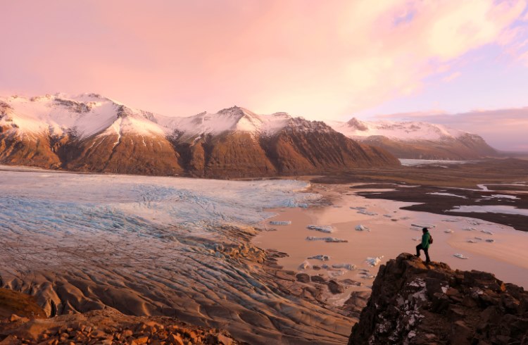 Photo © Getty Images / JurgaR
Vatnajökull National Park was created in 2008, when Iceland’s largest glacier was merged with two existing national parks, Skaftafell and Jökulsárgljúfur. Covering some 5,675mi2 (14,700km2), the park takes up nearly 15% of Iceland’s land mass. In other words, it’s huge.
In general, you can split the park up into two areas. There are the lowland regions, where access is easy, and the remote highland areas around the glacier itself, which are only accessible during summer.
- Getting to and around Vatnajökull National Park
- Vatnajökull Glacier
- Skaftafell Nature Reserve
- Jökulsárlón Glacier Lagoon
- Jökulsárgljúfur Canyon
- The highlands of Vatnajökull National Park
Getting to and around Vatnajökull National Park
The best way to visit the park is to rent a car or a campervan and explore at will. The easiest areas to access are Skaftafell, Jökulsárlón Glacier Lagoon, and Jökulsárgljúfur in the north, which you can visit year-round.
Visiting some areas of the park via public transport is possible. A bus goes from Reykjavik to Höfn five times a week, with stops at Skaftafell and Jökulsárlón. You could also catch a public bus to Akureyri and jump on a guided tour into Jökulsárgljúfur.
Visiting the remote highland areas of Vatnajökull National Park is more complicated. Keep in mind that all roads in the highlands are only accessible by 4WD during the height of summer – and even then, it’s never guaranteed. For most, joining a tour is easiest.
Vatnajökull Glacier
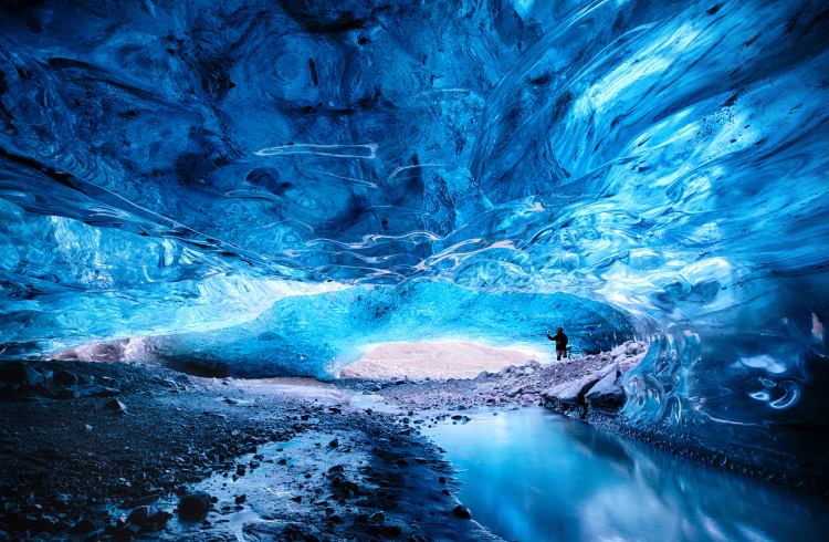
Vatnajökull, the glacier for which the national park is named, is the largest glacier in Iceland, and second largest in Europe by area, measuring around 2,973mi2 (7,700km2). To experience this ice cap in all its glory, I recommend going for a glacier hike or visiting one of the accessible ice caves in the winter. Guided tours leave from Skaftafell, Jökulsárlón, and the town Höfn.
Skaftafell Nature Reserve
Overlooking the Skaftafellsjökull glacier tongue, the first thing that strikes me is how different this ice is from the glacier above. Dirty and ash-laden, the retreating ice has melted its way up the valley, revealing a pock-marked landscape of black sand and murky lagoons. Curving up into the mountains, it slowly turns from black into white, joining the larger ice cap above.
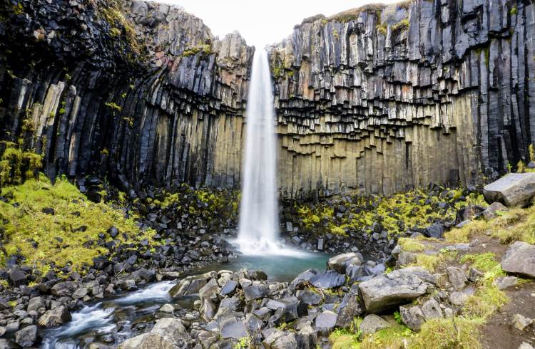
Such is the impressive vista from the Sjónarnípa viewpoint in Skaftafell, one of the many hiking trails inside this reserve nestled south of the glacier. The most famous sight here is the waterfall Svartifoss, a 90-minute return hike that takes you to a brilliant plume of water shooting off a cliff of black, hexagonal basalt columns.
Skaftafell is also a convenient spot to embark on guided hikes on top of the glacier, with several tour operators with offices in the parking area.
Jökulsárlón Glacier Lagoon
The second most popular area to visit inside Vatnajökull National Park is the Jökulsárlón Glacier Lagoon. Here, you can admire giant icebergs that have been carved off the retreating tongue of Breiðamerkurjökull. Sculpted into fascinating shapes by the fierce winds and strong tides as they float through the lagoon, the ice is eventually pulled out into the ocean, where the waves wash them back onto the coast of black sand, now known as Diamond Beach.
Like Skaftafell, access to Jökulsárlón is easy year-round (weather permitting – this is Iceland, after all). Once here, you’re free to wander around the shores of the lagoon, while boat, zodiac, and kayak tours allow you to venture out onto the lagoon itself.
Jökulsárlón also acts as a meeting point for tours that venture up onto the glacier. You could go hiking, ice climbing, or snowmobiling, and in winter there are also tours that visit the ice caves underneath Vatnajökull.
Jökulsárgljúfur Canyon
Separate from the rest of the park, the Jökulsárgljúfur Canyon is in northeast Iceland, connected to Vatnajökull via the long glacial river Jökulsá á Fjöllum. The river’s source sits near Bárðabunga, a brooding volcano underneath the ice of Vatnajökull. Ancient eruptions released powerful glacial floods down the river, carving out the canyon as we know it today.
You can access Jökulsárgljúfur from either the north or southern end, but it’s best done along road 862, which runs along the western side of the canyon. Aside from Dettifoss and Ásbyrgi, there are well-marked stops at Rauðhólar, a series of red scoria cones, and Hjlóðaklettur (singing cliffs), a set of ancient volcanic cores exposed after powerful floods.
Many people also choose to hike the length of Jökulsárgljúfur, camping half-way at Vesturdalur. The distance is 21mi (34km).
Dettifoss
I hear the roar of the water long before I see Dettifoss itself – if this is what it sounds like today, it’s nearly impossible to imagine the sound of a behemoth glacial flood. The dull roar turns into a barrage when Dettifoss comes into sight. A deluge of dirty brown water surges violently over the cliff’s edge, disappearing into the canyon below with an angry scream.
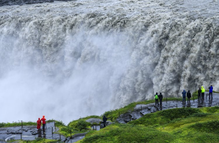
Dettifoss is Iceland’s most powerful waterfall, and one of its most impressive. An astonishing average of 51,000 gallons (193m³) cascades over the edge every second, plunging into the canyon below. It’s a mind-boggling amount of water, and only a fraction of the power a glacial flood would unleash.
While at Dettifoss, make sure to also follow a 1.5mi (2.5km) return trail south along the canyon to visit another waterfall, Selfoss.
Ásbyrgi
At the northern end of Jökulsárgljúfur is the incredible Ásbyrgi Canyon. This giant, u-shaped imprint in the earth is said to have been made by Odin’s horse, Sleipnir, stepping down from the heavens. Much more likely, it’s the work of another glacier flood, seeping in through the bedrock and blasting out the formation in a couple of days. Whether you believe the geologists or Icelandic folk lore, there’s no questioning that this is one of the country’s most impressive natural attractions.
At the top end of Ásbyrgi is the visitor’s center for the Jökulsárgljúfur area. Hiking trails leave from here and track up around the rim of the canyon. You can also drive down to the base of Ásbyrgi, where a scenic forest and pond sit at the bottom of the canyon walls that soar up around 330ft (100m).
The highlands of Vatnajökull National Park
The rest of the territory of Vatnajökull National Park consist of remote highland areas. Only accessible in the summer and with a 4WD, for adventure-enthusiasts seeking out some of Iceland’s most astonishing and powerful landscapes, this is for you.
In 2018, a proposal was put forth to expand Vatnajökull National Park to cover most of the Highland region. As of writing, the expansion has yet to be realized, but there’s still a dizzying amount of jaw-dropping scenery to gape at.
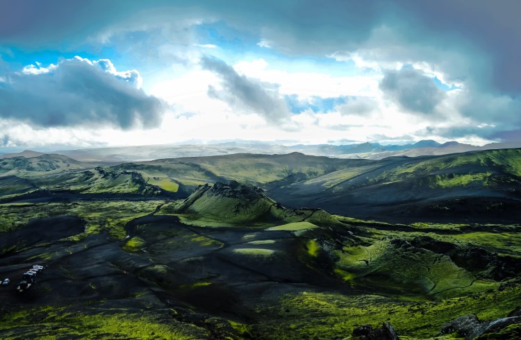
To the southwest of the glacier is the epic crater row called Lakagígar, remnants from the violent eruption of Laki in 1783 whose giant ash cloud sparked widespread famine across Europe. To the north is the desolate sub-arctic desert Ódáðahraun, an active volcanic zone scarred from countless eruptions. Then to the east, the cone-shaped peak of Snæfell, standing at 6,013ft (1,833m) and home to wild herds of reindeer roaming across the plains of rock, moss, and wildflowers.
Related articles
Simple and flexible travel insurance
You can buy at home or while traveling, and claim online from anywhere in the world. With 150+ adventure activities covered and 24/7 emergency assistance.
Get a quote
No Comments